Natural Resources and Agriculture
 The Natural Resources Chapter of the Tompkins County Comprehensive Plan aims to preserve and enhance the County's natural features and working rural landscapes. To achieve this, the County supports policies that preserve ecosystems, protect farmland, reduce the impacts of invasive organisms and climate change, and promote best management practices. For more details, please refer to the Natural Resources Chapter(PDF, 11MB) of the Tompkins County Comprehensive Plan.
Tompkins County Agricultural Districts
Tompkins County is concluding the eight-year review of NYS Certified Agricultural District #2, including land in the Towns of Newfield, Enfield, Ulysses, Ithaca and parts of Danby (approximately 67,100 acres total). The Tompkins County Agriculture and Farmland Protection Board (AFPB) has worked with Cornell Cooperative Extension to prepare the Agricultural District 2 2024 8-Year Review Draft Report(PDF, 5MB) that includes a map of the proposed changes to the District and a list of the parcels recommended for removal and addition to the District.
Tompkins County has two Agricultural Districts. Agricultural District 1, which generally runs through the municipalities on the East side of Cayuga Lake, and Agricultural District 2, which runs through municipalities on the West side of Cayuga Lake.
2020 Map of Tompkins County Agricultural Districts(PDF, 14MB)
Updates to Agricultural District 1 were made in 2020
Summary of 2020 Updates to Tompkins County Agricultural District 1 (East Side of Lake)(PDF, 2MB)
Consistent with NYS Agriculture & Markets Law Article 25AA section 303-a, the County Legislative body must conduct a review of the District every eight years after District creation and every eight years thereafter. Property owners can apply annually to have property considered for inclusion into the Agricultural Districts. Removals from the District can only occur during the 8 year updates.
Conservation Strategy
The Tompkins County Conservation Strategy (2012)(PDF, 447KB) presents 11 specific strategies to conserve critical identified resources in the County over a 10-year period. This strategy is based on the recommendations of the Tompkins County Conservation Plan, which includes analysis, findings and recommendations for both natural and agricultural resources. Other agency and community partners’ plans were also considered in the development of this strategy. The Tompkins County Conservation Strategy recognizes that protection of Tompkins County’s natural and agricultural heritage requires coordination with agency and community partners and collaboration with willing and interested landowners in the County. The final Conservation Strategy was endorsed by the Tompkins County Legislature October 2, 2012.
Programs
Natural Infrastructure Capital Program
The Natural Infrastructure Capital Program(PDF, 134KB) provides funding to protect natural systems that can help mitigate the adverse impacts of climate change. At this time, the focus is on: 1) mitigating the potential for downstream flooding and sedimentation, and 2) establishing important migratory corridors to enable plant and animal species to be more resilient in the face of a changing climate.
Have a project for the Natural Infrastructure Capital Program? Please submit the Natural Infrastructure Capital Program Application(PDF, 219KB) for consideration.
Purchase of Development Rights (PDR)
 Purchase of Development Rights (PDR) programs pay farmers who voluntarily commit to protecting their farmland from development through agricultural conservation easements. Funding pays the farmer the appraised difference between the “development value” of the land and the “agricultural value” of the land. When a farmer enters into a conservation easement, certain development rights are removed though the farmer retains ownership and agricultural use of land. Farmers, municipalities, and conservation partners, like land trusts, work together to establish and implement these projects. Municipalities and conservation partners annually monitor to ensure easement conditions are met. These programs can provide landowners with capital that can help enhance the economic viability of their farm operations or help transition farm ownership while also protecting the long-term legacy and environmental assets of the farm.
Tompkins County, in close cooperation with Cornell Cooperative Extension, the New York Agricultural Land Trust, the Finger Lakes Land Trust, and municipal governments, works with farmers to access New York State's PDR program. The state's program is called the Farmland Protection Implementation Grants Program and is administered through the NYS Department of Agriculture and Markets. It is a highly competitive statewide program that typically has one award cycle every other year. There are multiple funding categories for this grant, with specific eligibility criteria depending on the type of farm and the type of project. To find out if your farm might qualify you can review the summary of the current funding categories(PDF, 177KB) for our region.
The County Agriculture and Farmland Protection Board is responsible for selecting and ranking potential projects during a pre-application process. The pre-application process begins in the spring of even numbered years (e.g. April 2024) and pre-applications are due the following August. For more information, email Cornell Cooperative Extension of Tompkins County.
Interested? Complete the 2024 Tompkins County FPIG Pre- Application(PDF, 495KB).
Important dates and information regarding the 2024 Tompkins County FPIG Pre-Application:
Data, Maps, and Surveys
Natural Features Focus Areas
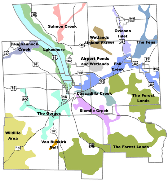
 Each of the 14 Natural Features Focus Areas included in the Tompkins County Comprehensive Plan has an individual plan that provides detailed information about the unique characteristics of the area and outlines a tailored approach to implementation.
- Salmon Creek(PDF, 3MB)
- Owasco Inlet(PDF, 2MB)
- Taughannock Creek(PDF, 2MB)
- Wetlands Upland Forest(PDF, 1MB)
- The Fens(PDF, 1MB)
- Lakeshore(PDF, 2MB)
- Airport Ponds and Wetlands(PDF, 1MB)
- Fall Creek(PDF, 3MB)
- Cascadilla Creek(PDF, 2MB)
- The Forest Lands(PDF, 2MB)
- The Gorges(PDF, 5MB)
- Sixmile Creek(PDF, 3MB)
- Wildlife Area(PDF, 1MB)
- Van Buskirk Gulf(PDF, 979KB)
Additional Maps
Tools, Links, and Resources