Flood Insurance Rate Map (FIRM) Tools
This product was specifically designed by FEMA for Tompkins County. If you need assistance with this product, call 211.
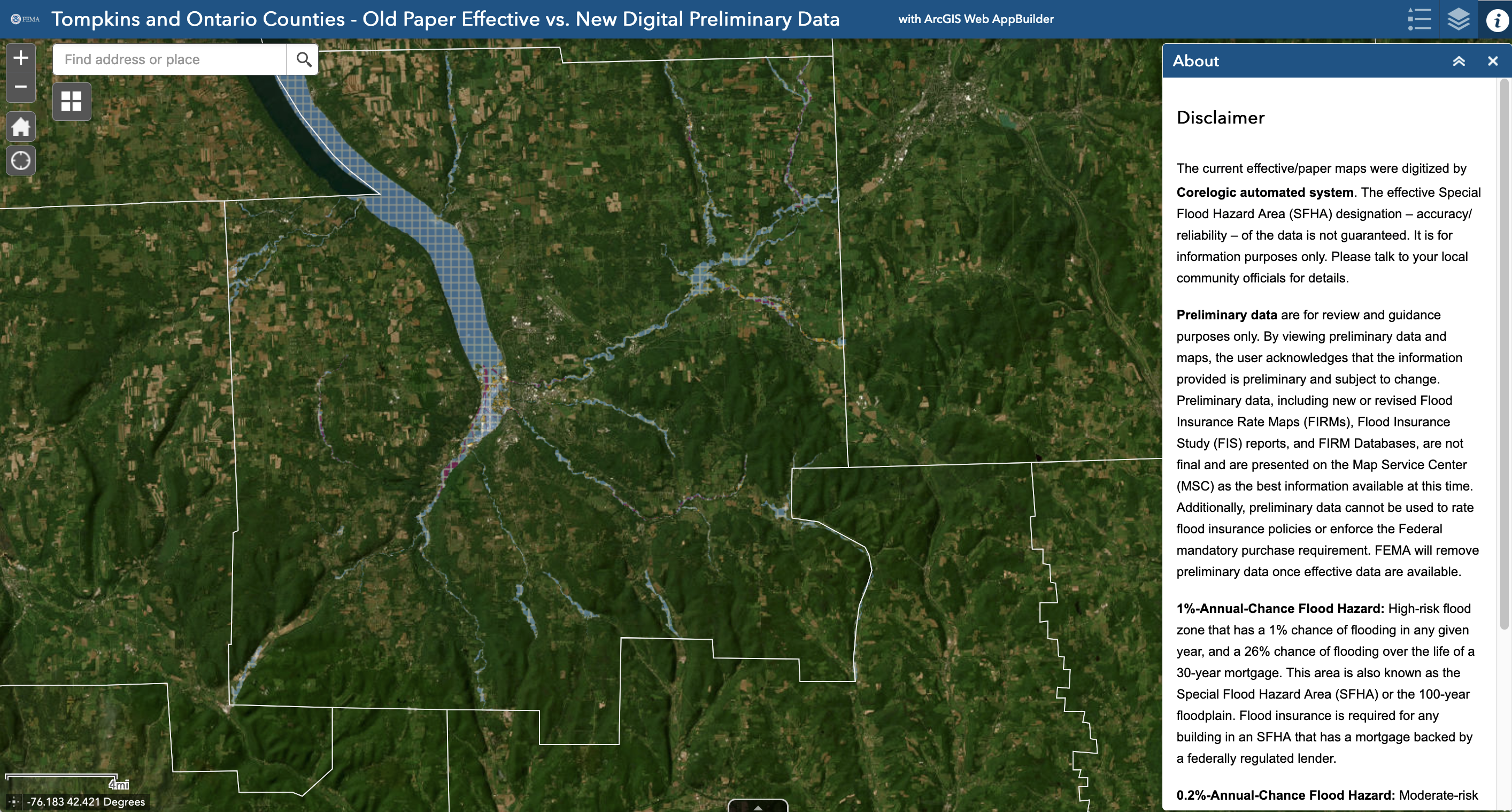
This product is intended to assist users in learning more about the flood risk of their properties. The current, effective FIRMs for Tompkins County are paper maps dating from the 1980s and have now been digitized in this product – you will see those labeled as CoreLogic.
To use FEMA's FIRM Viewer of Tompkins County, type an address in the upper left corner and click the magnifying glass button. The map will then center on that property. Use the Legend to interpret the map. Use the Helpful Definitions and Using the Map Viewer sections for assistance, or call 211.
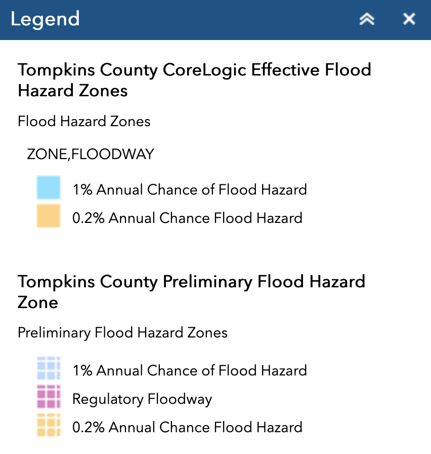 The solid colored layers are the current effective maps (on the legend and layers as "CoreLogic Effective Flood Hazard Zones"), and the hashed/patterned layers are the new Preliminary flood maps (on the legend and layers as "Preliminary Flood Hazard Zones").
Properties that are in the 1% Annual Chance of Flood Hazard (also known as the Special Flood Hazard Area, Zones A or AE, or 100 year flood zone) are the properties where federally backed mortgage holders will be required to purchase flood insurance when the maps become final. Property owners in these areas are encouraged to call their insurance agents. See the Flood Insurance section for more information.
Properties that are in the 0.2% Annual Chance of Flood Hazard (also known as the 500-year flood zone) and all other areas should consider their flood risk. These properties will not be required to purchase flood insurance.
With a high percentage of rental properties in Tompkins County, renters are encouraged to consider contents-only flood insurance, which can help protect items inside of a unit in the event of a flood.
Helpful Definitions to Interpret the Map
CoreLogic Effect Flood Hazards (Solid colors on the map) = Current Effective Paper Flood Maps that have been digitized
Preliminary Flood Hazard Zone (Hashed/patterned colors on the map) = New preliminary FEMA Flood Maps
1% Annual Chance of Flood Hazard = 100-year flood zone = Special Flood Hazard Area
0.2% Annual Chance Flood Hazard = 500-year flood zone
Using the Map Viewer
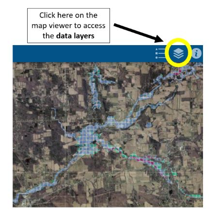 When the mapper opens, only the new preliminary maps (listed on both the legend and the layers as “Preliminary Flood Hazard Zone”) will be visible. If you are interested in comparing the new Preliminary maps with the current effective digitized paper maps (listed on both the legend and the layers as “CoreLogic Flood Hazard Zones”) you will need to turn that data layer on. There are more data layers on the map, including the current effective digitized paper maps (listed on both the legend and the layers as "CoreLogic Flood Hazard Zones"). If you are interested in viewing these additional data layers, locate the icon that looks like a stack of papers, circled below in yellow in the top right corner of the viewer, to be able to turn the data layers on and off.
 By checking and unchecking items from the Layer List that has appeared, you will be able to add and/or take away data from the map viewer. If you are interested in only viewing the newly released maps, make sure that “Preliminary Flood Hazard Zone” is checked and that “CoreLogic Effective Flood Hazard Zones” is unchecked.
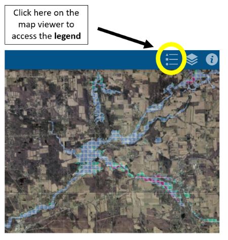
To access the legend, navigate to the item circled below in yellow in the top right corner of the map viewer
Additional Mapping Information
- FEMA's FIRM Viewer of Tompkins County gives residents a way to view the maps that affect their specific locations.
- FEMA’s Flood Map Service Center website is a source for information. The site includes all of FEMA’s flood maps and data. It also has fact sheets about flood insurance, Risk MAP, ways to mitigate flood risk, and related information.
- Map specialists at the FEMA Mapping and Insurance eXchange (FMIX) can be reached at (877) 336-2627 or FEMA-FMIX@fema.dhs.gov.
- Paper maps are available in your local city, village, or Town Hall. If you have questions about your municipality's flood risk or rate maps, contact your municipality to schedule a time to review the maps.
- If you feel your property is at risk of flooding, you can still buy flood insurance, regardless of your FEMA flood zone.