
Water Resources
Contents Projects ♦ Programs ♦ Plans and Studies ♦ Data, Maps, and Surveys ♦ Tools, Links, and Resources
The Water Resources Chapter (7.86 MB) of the Tompkins County Comprehensive Plan states that
Tompkins County should be a place where water resources are clean, safe, and protected.
It is the policy of Tompkins County to:
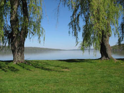
- Protect the ecological, economic, and recreational functions of Cayuga Lake.
- Protect aquifers from contamination by limiting development within groundwater recharge areas.
- Protect streams and their watersheds to maintain water quality, manage stormwater and flooding, and enhance ecological diversity.
- Preserve existing wetlands and restore wetland functions.
- Support water-dependent or -enhanced development of the City’s urban waterfront while conserving important natural resources and providing public enjoyment of the waterfront.
Projects
Ludlowville Stormwater Control Project
Ludlowville, located in northeastern Tompkins County, has experienced repeated, localized flooding associated in large storm events. Area property owners are concerned about increased flood events associated with stormwater. There is a need for a specialized study of the area’s hydrology and the development of an engineered system to assist in reducing the damage associated with these stormwater events. The Ludlowville Stormwater Control Project is a joint effort of Tompkins County and the Town of Lansing in three distinct and consecutive phases: Project Feasibility Study, Alternatives Analysis, and construction, all of which can be found on the project's webpage.
Programs
Stream Corridor Restoration & Flood Hazard Mitigation Program
Since 1983, the Tompkins County Legislature has periodically funded a program to help residents and municipalities minimize property damages associated with future flood events. Program funds have been used to complete watershed assessments for the Six Mile Creek, Fall Creek, Salmon Creek, Cayuga Inlet, Taughannock Creek, and Buttermilk Creek watersheds. These assessments helped the County to (1) develop a better understanding of the complexity of and inter-relationships between factors that influence flooding and erosion in the respective watersheds of Tompkins County and (2) develop a list of priority flood-related projects (including those related to erosion and sedimentation).
For more information about this program, visit the program's webpage, or contact the Tompkins County Planning and Sustainability Department or the Tompkins County Soil and Water Conservation District.
Tompkins County Aquifer Program
In partnership with the United States Geological Survey (USGS), Tompkins County provides funding for an aquifer study program to help protect Tompkins County’s groundwater resources and drinking water supplies. County funds from this program leverage Federal funds to conduct consecutive studies of individual aquifers in the County. Participating municipalities also provide a portion of the necessary funding. The products of the studies are unique to each aquifer and generally include investigation of surface water and groundwater interaction, groundwater movement, and vulnerability of the respective groundwater resources. A list of completed studies can be found below, under Data, Maps, and Surveys.
Plans and Studies
Tompkins County Harmful Algal Bloom Strategy
With an increase in harmful algal blooms (HABs, cyanobacteria) across New York, in 2018 Governor Cuomo allocated $65 million to address the issue. New York State HABs Action Plans were drafted for twelve priority waterbodies, including Cayuga and Owasco lakes. The challenge for agencies, municipalities, and watershed partners is to implement the priority projects in a meaningful way that safeguards water quality and reduces HABs.
The Tompkins County Harmful Algal Bloom Strategy focuses on actions to be undertaken in the next three years by Tompkins County departments and partners/agencies working in the county.
Enhancing Water Resources in Tompkins Co.: Benefits of Riparian Areas & Stream Buffers (1.51 MB)
NYS Local Waterfront Revitalization Program: Cayuga Lake Waterfront Plan (12.63 MB) (2004)
Tompkins County Conservation Strategy (322 KB) (2012)
Data, Maps, and Surveys
Wetland Mapping for Tompkins County, New York
Aquifer Studies
- Upper Sixmile Creek and West Branch Owego Creek Valleys (2009)
- Lower Sixmile Creek and Willseyville Creek Trough (2010)
- Cayuta Creek and Catatonk Creek Valleys (2012)
- Virgil Creek and Dryden Lake Valleys (2013)
- Pony Hollow Creek Valley (2014)
- Upper Buttermilk Creek and Danby Creek Valleys (2015)
- Enfield Creek Valley (2019)
- Owasco Inlet Valley (2023)
- Lower Fall Creek (in development)
Tools, Links, and Resources
Stormwater Coalition of Tompkins County